An El Niño is currently underway here in the tropical Pacific region.
Oceanic indicators firmly exhibit an El Niño state whereby Pacific Sea surface temperatures (SSTs) in the central region have peaked and are currently declining. Models also indicate an expected return of the El Niño–Southern Oscillation (ENSO) to neutral levels in autumn 2024.
Atmospheric indicators over the tropical Pacific are reflected close to normal levels, although trade winds have temporarily weakened in line with the passage of the Madden-Julian Oscillation through the region. The Southern Oscillation Index (SOI) has recently increased.
The Indian Ocean Dipole (IOD) has returned to neutral, being below +0.4 °C. IOD events typically break down as the monsoon trough shifts south into the southern hemisphere. Due to the strength of the positive IOD in 2023, the event decay has been later than usual. The majority of model forecasts indicate the IOD will be neutral until at least April, consistent with the annual cycle of the IOD.
The Madden–Julian Oscillation (MJO) is currently over the central Pacific. International climate models suggest the MJO is likely to remain in the central Pacific during the coming fortnight. When the MJO is in the central Pacific region, it may also weaken trade winds in the central to western Pacific, which is likely to temporarily stall cooling SSTs associated with El Nino decline; SSTs across parts of the Pacific have indeed increased slightly over the past week.
Bulletin February 2024 - El Nino Oscillation
El Nino El Niño Southern Oscillation (ENSO) is at El Niño levels.
El Niño Southern Oscillation (ENSO) is a single climate feature that has three states: El Niño, La Niña, and Neutral.
During an El Niño, sea surface temperatures in the central and eastern equatorial Pacific, both at the surface and the sub-surface tends to WARM. Surface pressure changes across the Pacific; higher in the west, and lower in the east. Trade winds weaken and sometimes reverse. Cloudiness increases near the Date Line. El Niño events tend to develop in Autumn to Winter (March - August), and starts to decay in Summer (December - February). In Vanuatu, extreme below normal rainfall which results in drier conditions with warmer daytime temperatures are associated with El Niño.
During a La Niña, sea temperatures in the central and western equatorial Pacific, both at the surface and the sub-surface tends to WARM. Surface pressure changes across the Pacific; higher in the east, and lower in the west. Trade winds are much stronger than normal. Cloudiness decreases near the Date Line. La Niña events also tend to develop in Autumn to Winter (March - August), and finishes the following Autumn (March - May). In Vanuatu, above normal rainfall which results in extreme wetter conditions with cooler temperatures are associated with La Niña.
During a Neutral phase, all ENSO indicators (Sea surface temperatures, Southern Oscillation Index (SOI), trade winds, and cloudiness near the Date Line) in the tropical Pacific Ocean, remain within the neutral range. Normal climate conditions are experienced over Vanuatu during Neutral ENSO phase.
Bulletin February 2024 - MJO
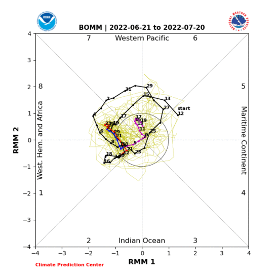
What is an MJO (Madden-Julian Oscillation)? An MJO is a group of clouds and rain that circulates the globe near the equator and usually occurs every 30-60 days. When an MJO passes over an area, it brings heavy rain with varying wind speeds. During cyclone season, an MJO can help develop tropical cyclones by fueling any overlying low-pressure systems.
The diagram below shows the track of the MJO for the past 40 days (colored lines). [Click to enlarge the diagram]. When the lines are within the circle, MJO is weak and does not influence rainfall. Outside the circle, the MJO is active and will usually move in an anti-clockwise direction. Vanuatu will most likely experience rainfall related to an MJO event when it moves over the Maritime Continent on the diagram.
Note: Due to frequent images update from source provider, the quoted Sources might not give the same images as shown
Bulletin February 2024 - Cloud
The above maps show regions experiencing more or less cloudiness. The top map is the total outgoing long-wave radiation (OLR), and the bottom map is the cloud anomaly. Outgoing longwave radiation (OLR) is often used as a way to identify tall, thick, convective rain clouds. This means a region that experiences lower outgoing radiation is an indication of more cloudiness over the area.
The purple shading indicates higher than normal, active, or enhanced tropical weather (above normal cloudiness), while the brown shading indicates lower than normal cloud or suppressed conditions.
Equatorial cloudiness near the Date Line typically increases during El Niño (negative OLR anomalies) and decreases during La Niña (positive OLR anomalies).
Note: Due to frequent images update from source provider, the quoted Sources might not give the same images as shown
Bulletin February 2024 - Rainfall
Seasonal outlook for March and March to May 2024.
On average, rainfall is likely to be below normal in Sanma and part of Torba, and very likely to be below normal elsewhere for March. However, it is likely to be below normal in Malampa, Penama, and Torba while very likely to be below normal in Sanma, Shefa, and Tafea from March to May 2024.
Note: Due to frequent images update from source provider, the quoted Sources might not give the same images as shown
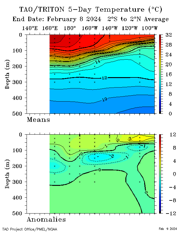
Bulletin February 2024 - SST
For the 5 days ending 4 February 2024, sub-surface temperatures were more than 2 °C warmer than average across the top 50 m of the equatorial Pacific east of 140°W. Elsewhere, anomalies in the western and central Pacific were generally within 1 °C of average. An area of cool anomalies was present between around 100 and 200 m depth in the central equatorial Pacific, reaching more than 2 °C cooler than average.
Compared to last fortnight, the magnitude of warm anomalies in the central and eastern Pacific has decreased, while the area of cool anomalies below 100 m has moved slightly eastwards.
Note: Due to frequent images update from source provider, the quoted Sources might not give the same images as shown
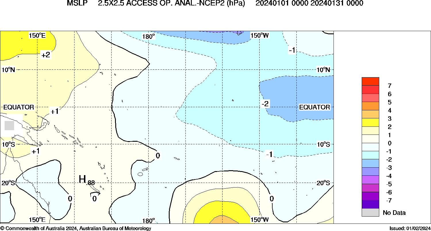
Bulletin February 2024 - MSLP
Regions of HIGH pressure anomalies (brown shades) are associated with lower rainfall, while higher rainfall are associated with regions of LOW pressure anomalies (purple shades).
Note: Due to frequent images update from source provider, the quoted Sources might not give the same images as shown
Bulletin February 2024 - Model Outlooks
International model forecasts and observations indicate warming of the equatorial Pacific has peaked and is now declining. Sea surface temperatures in the tropical Pacific are expected to return to neutral levels (neither El Niño nor La Niña) in the southern hemisphere in autumn 2024. Six of seven models indicate a return to neutral by May, with the seventh model returning to neutral in June.


